
The Mind-Blowing Judean Desert: David Flees from Saul, Jesus Confronts the Devil, and Monks See It as Paradise. And That's Before We Even Talk About the Dead Sea and the Bungee-Jumping Clouds.
- Nir Topper

- Jul 10, 2025
- 7 min read
Israel, despite its small size, is characterized by a rich variety of geographical and climatic regions. Just a few examples of this diversity include the Coastal Plain, the Shephelah (foothills), the central mountain spine, the northern valleys, the Galilee mountains, and the Golan Heights. The largest geographical region in Israel is the desert, which constitutes about two-thirds of the country's area.
What is a Desert? The globally accepted definition of a desert is a region with an average annual precipitation of less than 200 millimeters.
Where is the Desert in Israel? Israel has several desert regions, each differing in its geographical and climatic characteristics:
The Negev: The largest desert in Israel, sprawling over approximately 13,000 sq km, making up about 60% of the country's territory. It is divided into sub-regions like the Northern Negev, the Negev Highlands, and the Arava Valley. The Negev is part of the world's desert belt, a band of deserts that encircles the Earth around the 20-30 degree latitudes north and south, formed by global climatic processes. Other deserts in this belt include the Sahara Desert in Africa, the Sonoran Desert in North America (United States and Mexico), and the Atacama Desert in South America.
The Arava: A long, narrow valley stretching from the Dead Sea to Eilat. It is the most arid and hottest region in Israel.
The Judean Desert: A unique desert located east of the Judean Mountains and Jerusalem, bordering the Dead Sea and the Jordan Valley. As I will explain shortly, it is defined as a "rain shadow desert."

The Judean Desert
The Judean Desert is one of the most fascinating and richest regions in Israel in terms of its history, religion, geography, geology, and landscape.
Why is it Called the "Judean Desert"? The Judean Desert is named for its historical location within the territory of the tribe of Judah. Its name has been preserved through generations in various sources and languages:
In the Hebrew Bible (Tanakh): It is explicitly mentioned as the "Wilderness of Judah." One source is the Book of Judges 1:16: "Now the descendants of the Kenite, Moses’ father-in-law, went up from the City of Palms with the people of Judah to live among the people of the Wilderness of Judah in the Negev near Arad."
In the New Testament: It is called the "Wilderness of Judea." One source is the Gospel of Matthew 3:1: "In those days John the Baptist came, preaching in the wilderness of Judea and saying, 'Repent, for the kingdom of heaven has come near.'" In the original Greek: "ἡ ἔρημος τῆς Ἰουδαίας" (hē erēmos tēs Ioudaias).
In Latin: Desertum Iudaeae.
In Arabic: It is called "صحراء يهودا" (Ṣaḥrāʾ Yahūdā) and more often "برية القدس" (Bariyat al-Quds), meaning "The Wilderness/Wasteland of Jerusalem."
In English: "Judean Desert." The Quran does not mention the Judean Desert by name, but the region is part of the Holy Land, central to the stories of many prophets mentioned within it.
"Rain Shadow Desert" The primary phenomenon that defines the Judean Desert is its status as a “Rain Shadow Desert.” Clouds arriving from the west, from the Mediterranean Sea, are forced to ascend over the Judean Mountains ridge to altitudes of about 800 meters above sea level. During this ascent, the air in the clouds cools, and their moisture condenses and falls as rain on the western slopes of the mountains and along the watershed line (for example, in Jerusalem and Gush Etzion).
Because of the unique topographical structure of the Judean Desert, when the clouds cross the ridge line, they perform a "bungee jump" of about 1,200 meters down the very steep slopes of the western Judean Desert towards the Dead Sea (the lowest point on Earth). In the process of this extreme descent eastward—from 800 meters above sea level to 400 meters below sea level over an almost negligible distance—the clouds heat up and dry out even more, which prevents the formation of rain clouds. As a result, the region east of the Judean Mountains receives a minimal amount of precipitation, turning it into an arid desert despite its relative proximity to the Mediterranean Sea.

The Judean Desert - Area, Geology, and Characteristics
Area: The area of the Judean Desert is approximately 1,500 sq km.
Fauna and Flora: Despite the arid conditions, the Judean Desert is home to a surprising variety of animals and plants that have adapted to the harsh environment:
Fauna: The most iconic mammal of the desert is the Nubian Ibex, which can be seen on the cliffs of Ein Gedi. In addition, you can find Rock Hyraxes, gazelles, wolves, hyenas, and until the recent past, even leopards. The birdlife is rich and includes vultures, Egyptian vultures, and many species of songbirds.
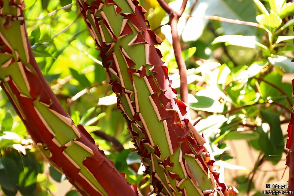
Flora: Vegetation is sparse and consists mainly of drought-resistant shrubs and grasses. In the oases, like Ein Gedi and Einot Tzukim, freshwater springs emerge, allowing for the lush growth of palm trees, common reeds, and abundant riverbank vegetation, creating a stunning contrast to the arid surroundings.
History and Religious Significance
Throughout history, the Judean Desert has served as a place of refuge, solitude, and concealment, and it holds immense importance for the three monotheistic religions.
In Judaism:
King David: According to the Bible, the young David fled to the Judean Desert from King Saul and found shelter in its caves and natural strongholds, such as in the Ein Gedi area.
Judean Desert Sects: During the Second Temple period, the desert was home to sectarian groups who separated from the religious establishment in Jerusalem, the most famous of which is the Essene sect. They lived a communal and pure life, leaving behind the Dead Sea Scrolls, which were discovered in the Qumran caves – one of the most important archaeological discoveries of the 20th century.
The Bar Kokhba Revolt: The warriors of Bar Kokhba used the caves of the deep canyons of the Judean Desert as their last hiding places in their fight against the Romans.
In Christianity:
John the Baptist and Jesus: According to the New Testament, John the Baptist was active and baptized in the Judean Desert, near the Jordan River. Jesus himself retreated to this desert for 40 days and nights, where he faced the temptations of the devil.
Monasticism: Starting in the 4th century CE, the desert became a vibrant center of monasticism. Hermit monks established spectacular monasteries carved into the rock, such as the Mar Saba Monastery and St. George's Monastery (Deir al-Qelt) in Wadi Qelt.
In Islam:
The Prophet Muhammad's Night Journey: According to Islamic tradition, during the "Night Journey" (Al-Isra' wa'l-Mi'raj) from Mecca to Jerusalem, the Prophet Muhammad passed through the Judean Desert region.
Nabi Musa: Muslim tradition identifies the site of Nabi Musa in the Judean Desert as the burial place of Moses (contrary to Jewish tradition). The site has been an important pilgrimage center for hundreds of years. Additionally, the desert is a vital living area for Bedouin tribes.
Major Streams and Attractions for Hikers
The Judean Desert is a popular destination for hiking, jeep tours, and rappelling.

Major Streams:
Nahal Prat (Wadi Qelt): A perennial stream with pools and a spectacular hanging monastery.
Nahal Og: A short and impressive canyon with water pools after floods.
Ein Gedi Streams (Nahal David and Nahal Arugot): A nature reserve with waterfalls, pools, ibexes, and rock hyraxes.
Nahal Darga (Darajeh) and Nahal Mishmar: Challenging canyons that involve descending via ladders and dry waterfalls.
Special Sites and Attractions:
Masada: An ancient fortress on an isolated cliff, a symbol of Jewish heroism, and a UNESCO World Heritage Site.
Qumran: The archaeological site where the community of the Dead Sea Scrolls lived.
Einot Tzukim (Ein Feshkha): A nature reserve with freshwater and saltwater pools on the shore of the Dead Sea.
The Good Samaritan Inn: An archaeological site and mosaic museum that reconstructs an ancient roadside inn.
Viewpoints: Mitzpe Yericho, Mitzokei Dragot, and others offer breathtaking panoramic views of the desert and the Dead Sea.
The Dead Sea: A Unique World Wonder
The Dead Sea, bordering the Judean Desert to the east, is an extraordinary natural phenomenon on a global scale and an inseparable component of the region's landscape and history.
Formation and Salinity: The Dead Sea is an endorheic lake (with no outlet to another sea) located at the lowest point on Earth, in the heart of the Syrian-African Rift Valley. The hot and dry desert climate causes intense evaporation of the water, but the salts and minerals that have flowed into it over millions of years remain behind. This process has resulted in an extreme salt concentration of about 34%, nearly ten times the salinity of the Mediterranean Sea (about 3.5%). This high salinity is the reason why there is almost no life in the water, earning it the name "Sea of Death." It is also the reason for the famous buoyancy phenomenon: the specific gravity of the water, saturated with salts, is higher than that of the human body, so the body floats effortlessly on the surface.
Global Uniqueness:
The Lowest Place on Earth: Its shores are the lowest terrestrial point on the globe.
Buoyancy: The high salinity creates water density that allows for effortless floating.
Natural Treasures: Its waters and the black mud at its bottom are rich in minerals with recognized medicinal properties.
Resources: Potash (used for fertilizer production), bromine, magnesium, and more are extracted from the sea.
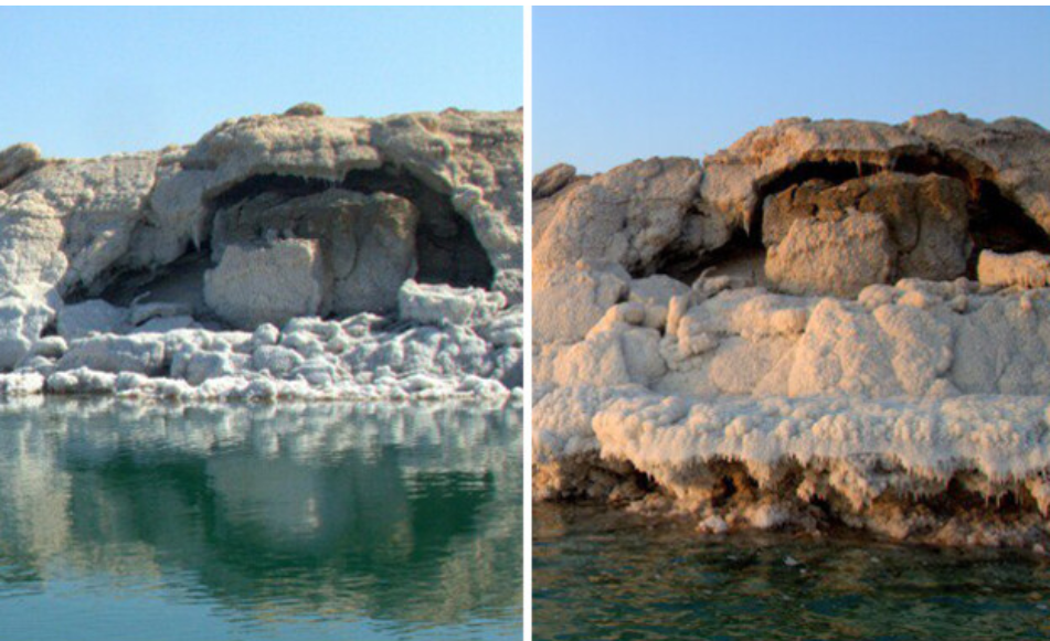
The Receding Level - The Great Challenge: Unfortunately, this natural wonder is in danger. The sea level is dropping at an alarming rate of about one meter per year.
Causes of the Recession: The main cause is a "negative water balance" – the amount of water evaporating and being pumped out is far greater than the amount of water flowing in. This is due to a combination of man-made factors: the construction of the Degania Dam, which stopped the flow of the Southern Jordan River (the sea's main source); the construction of dams by Jordan that stopped the flow of streams from the east; and massive water pumping by the Dead Sea Works in Israel and Jordan for evaporation ponds and mineral extraction.
Historical Evidence on the Rock: Alongside Route 90, south of the Qalya Junction, one can see a moving testimony to the receding waterline. Engraved on a prominent rock are level markings made by the British Palestine Exploration Fund (PEF). The upper mark is from the year 1900, and the lower one is from 1917. The expedition members reached the rock by boat, at a spot that today is located far above a busy asphalt road. These markings illustrate the dramatic drop in the waterline.

Numerical Data: Official measurements confirm the grim picture. In 1900, the level stood at -392 meters below sea level, and its surface area was about 1,020 sq km. By December 2020, the level had plummeted to -435 meters, and its area had shrunk to only about 605 sq km. This is a drop of 43 meters in the water level, which means a loss of over 43 billion cubic meters of water – an enormous quantity that illustrates the scale of the ecological disaster.
Photos documenting the receding waterline of the Dead Sea, from: https://www.mako.co.il/news-science/2023_q1/Article-219edf0dc220681027.htm (Link in Hebrew)


Comments