
The Victorian Revolution That Changed Everything We Knew About the Land
- Nir Topper

- Feb 23
- 4 min read
Updated: Feb 26
In 1865, in Victorian London, the Palestine Exploration Fund (PEF) was established. It was an organization that would dramatically influence—some scholars argue more than any other research group—the way we understand the history of this land. Although most of its members came from a Christian-religious background, this was not a religious study by clergy; it was a fascinating blend of British imperial interests, military engineering, and uncompromising scientific curiosity. It marked the transition from amateur exploration to systematic, empirical, and scientific research.
One of the most captivating figures in this story is Charles Warren, a British military engineer who excavated deep vertical shafts outside the Temple Mount walls and horizontal tunnels beneath them. Since Ottoman authorities prohibited digging inside the compound, Warren bypassed the ban from below—sometimes in local dress and by bribing guards. He identified the Herodian courses of the Western Wall and proved that the modern city sits upon layers of ruins buried dozens of meters underground. Later, he turned south to the City of David, where he discovered an ancient vertical shaft near the Gihon Spring—still known as "Warren's Shaft" today. While Warren believed the shaft was used to draw water into the fortified city, later excavations revealed it to be a natural karstic chimney formed by geological processes, rather than a man-made part of the ancient water system. Nevertheless, his work laid the foundation for the topographical understanding of Second Temple-era Jerusalem.
But the real revolution didn't just happen underground; it happened on the surface. The Survey of Western Palestine (SWP), conducted by the PEF in the 1870s, was arguably the most significant cartographic project in the history of the region. Claude Conder and Horatio Kitchener (who later became the British Secretary of State for War) mapped every mountain, village, and well from Tyre to Beersheba. They collected thousands of Arabic place names (research suggests over 9,000!), understanding that local names often preserved biblical memory. Their maps were so accurate that they remained in use by military forces and planning authorities well into the mid-20th century.
In the 1890s, the Fund led another methodological revolution thanks to Flinders Petrie. During his excavations at Tell el-Hesi, Petrie realized for the first time that a "Tell" (mound) is actually a stack of cities built one on top of the other. He introduced the method of stratigraphy—excavation by layers—and combined it with his own innovation: pottery chronology. Suddenly, simple pottery shards became a scientific "clock" that allowed history to be dated with unprecedented precision. Archaeology evolved from a hunt for treasures into a science of data.
There was also a shadow side to the Fund’s activities: espionage. It is important to remember that the land was still part of the Ottoman Empire. On the eve of World War I, Leonard Woolley and T.E. Lawrence (famed as "Lawrence of Arabia") were sent to survey the Negev under the guise of archaeology. The official mission was to study the "Wilderness of Zin," but the true objective—ordered by Lord Kitchener himself—was the military mapping of desert routes toward Sinai and Egypt in preparation for the British invasion. The book they published, The Wilderness of Zin, remains a masterpiece that blends historical research with geographical and military insights.
Contrary to popular belief, the PEF never closed. It has operated continuously for 160 years from its headquarters in Greenwich, London, and holds a unique archive of over 40,000 photographs and maps of Israel, Jordan, and Syria. Throughout the 20th century, the PEF was a partner in excavations that yielded dramatic finds, such as the Samaria Ivories—magnificent works of art from the Kingdom of Israel. The Lachish Letters, discovered in 1935 in excavations where the PEF played a significant role, provided written evidence of the final days of the Kingdom of Judah before the Babylonian conquest.
👉Join one of my (quiet) Channels - Society, Culture & History:
Telegram: https://t.me/nirtopper
In conclusion, the Palestine Exploration Fund (PEF) is the founding force of modern archaeology and geography in our region. Through massive mapping projects, the pioneering excavations of Warren and Petrie, and the preservation of thousands of local place names, the Fund transformed the Land of Israel from a destination of emotional pilgrimage into a geographical and historical entity based on solid scientific data. Its contribution to research is unprecedented: it provided the infrastructure for understanding Jerusalem's topography, the first accurate map of the land, and the methodology still used by researchers today. The Fund's archive and the knowledge it accumulated remain a cornerstone for anyone seeking to deeply understand the roots of the past hidden between the layers of the earth.
Image 1: The PEF Logo. Source: Wikipedia.

Image 2: PEF Map of Jerusalem and its surroundings. Source: Wikipedia.
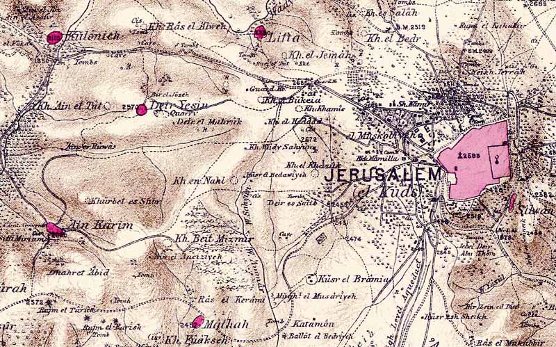
Image 3: PEF Survey of Palestine. Source: Wikipedia.

Image 4: Charles Warren's mapping team (Warren on left)

Image 5: Triangulation network created by the PEF mapping team.

👉Join one of my (quiet) Channels - Society, Culture & History:
Telegram: https://t.me/nirtopper
#nir_topper #tour_guide #archaeology #history #society #israel #travel #culture #ניר_טופר #מורה_דרך #ארכיאולוגיה #היסטוריה #ישראל #טיולים #תרבות #חברה #PEF #PalestineExplorationFund #Mapping #MiddleEast #Geopolitics #Heritage #LawrenceOfArabia #ScientificResearch #גאופוליטיקה #מורשת #ארץ_ישראל #מפות #מרגלים #ירושלים


Comments