
Between Walls of Ignominy and Gates of Paradise: 7,000 Years of Drama in Beit She’an - Scythopolis

Beit She’an is one of the most significant archaeological sites in the Middle East, boasting a continuous history of settlement spanning approximately 7,000 years. Situated at a strategic crossroads between the Jordan Valley, the Jezreel Valley, and the Harod Valley, its location granted it control over major ancient trade routes. The abundance of water from the Harod Stream and the fertile soil made this region a vital agricultural hub, as evidenced by some 20 layers of settlement unearthed at the Tel (mound), each telling the story of the empires that viewed it as a strategic asset.
The Egyptian Stronghold
During the Late Bronze Age (1550–1200 BCE), the city became the administrative and military center for the Egyptian Empire in northern Canaan. Written records, such as its mention in the Amarna Letters, and particularly the monumental stelae of Seti I and Ramesses II found at the site, testify to its status as a fortified administrative capital. Here, Egyptian cultic worship existed alongside local Canaanite beliefs, a synthesis reflected in the "Stele of the God Mekal" found at the site.
Biblical Tragedy and "Chariots of Iron"
The city’s military importance remained paramount during the Biblical period, when it was known as a Canaanite stronghold ruling with "chariots of iron." According to Biblical tradition, the Tribe of Manasseh was unable to conquer the city for a long period. However, the most dramatic Biblical narrative associated with the city is the defeat of King Saul in the Battle of Mount Gilboa against the Philistines. The Bible describes the bitter end of the battle and the desecration of the bodies of the King and his sons by the Philistines: "They put his armor in the temple of the Ashtoreths and fastened his body to the wall of Beth Shan" (1 Samuel 31:10). This act of humiliation and deterrence against the Israelites lasted until the men of Jabesh-Gilead came under the cover of night to rescue the bodies.
The Golden Age: Nysa-Scythopolis
The city’s architectural zenith arrived during the Roman period, when it was known as Nysa-Scythopolis. It was the leading city and the only one west of the Jordan River within the Decapolis (the "Ten Cities" — a league of Hellenistic-Roman cities). During this era, and especially following Emperor Hadrian's visit in the 2nd century CE, magnificent monumental structures were erected. Excavations have revealed and restored a 7,000-seat theater, an amphitheater for gladiator spectacles, and expansive bathhouses fed by a sophisticated system of aqueducts from Mount Gilboa.
Jewish Life and the "Entrance to Paradise"
Jewish history in Beit She’an saw many upheavals: from the massacre of 13,000 Jews at the beginning of the Great Revolt against Rome (66 CE) to the community's restoration during the Mishnaic and Talmudic periods. At the end of the 2nd century, Rabbi Yehuda HaNasi exempted the city from tithes (Terumot and Ma'aserot) after determining it was not included within the boundaries of those who returned from the Babylonian Exile. This Halakhic decree eased the burden on Jewish farmers and contributed to their economic prosperity. The 3rd-century sage Resh Lakish coined the famous saying: "If the Garden of Eden is in the Land of Israel, its gate is in Beit She’an."
The Byzantine Peak and the "House of Kyrios Leontis"
At the height of the Byzantine period (5th–6th centuries CE), Scythopolis served as the provincial capital and housed approximately 40,000 residents. The "House of Kyrios Leontis" discovered in the city reflects the character of the Jewish community: the complex features mosaics blending mythological scenes from the Odyssey alongside Jewish ritual symbols like the Seven-Branched Menorah, with inscriptions in both Hebrew and Greek. This combination tells the story of an affluent community that preserved its distinct culture while adopting the Hellenistic-Byzantine cultural language.
The Great Earthquake of 749 CE
The classical era of the city came to a catastrophic end on the morning of January 18, 749 CE, in a massive earthquake known as the "Sabbatical Year Earthquake" (named for the Shmita year in which it occurred). The sheer force of the tremor almost completely destroyed the city. Chilling evidence of the destruction's final moments was found in the form of a human skeleton trapped under a collapsed column, hand outstretched toward a hoard of coins. Was he rushing to save his wealth from a hiding place, or attempting to hide it quickly? Either way, he did not succeed. Among the coin hoards found at the site were coins dating to the 740s CE. These coins, minted following the monetary reforms of Caliph Abd al-Malik, bore only Arabic inscriptions without human figures. Muslim rule in the city had begun with the Arab conquest around 634 CE, at which point the Semitic name "Beit She’an" was restored in its Arabic version "Beisan," and the name "Scythopolis" was abandoned.
From Mamluk Sugar to Modern Times
Despite the destruction, Beit She’an remained a key hub during the Mamluk period (13th–16th centuries), becoming a global center for sugar production thanks to sophisticated water engineering that included underground tunnels. Following the Ottoman conquest in the 16th century, the city lost its administrative and economic standing; the ancient center was finally abandoned, and residents moved to the high plateau southwest of the ancient site.
There, upon the ruins of the past, the Arab village of Beisan developed. Its residents arrived mostly from the Hauran in Syria, from Egypt (during the 19th century following Ibrahim Pasha's campaign), and from the Jordan Valley. At its peak, on the eve of the 1948 War of Independence, the village had over 5,000 residents and served as an economic and administrative center for the surrounding villages. The village’s history ended during the war; on May 12, 1948, during "Operation Gideon," Beisan was captured by Golani Brigade forces. Most residents left during the battles or were evacuated to Jordan shortly thereafter. The modern settlement we know today was established on and near this infrastructure, while the monumental ancient city remained in ruins, buried under layers of silt and earth until the major excavations of the 20th century began.
--
---
----
👉Join one of my (quiet) Channels:
Telegram: nirtopper.com/telegram-channel
Whatsapp: nirtopper.com/whatsapp-channel
👉Rich content available for you on my Blog; Israel's History, Society & Culture:
Image 1: The Roman Theater, Scythopolis. Photo: Nir Topper.
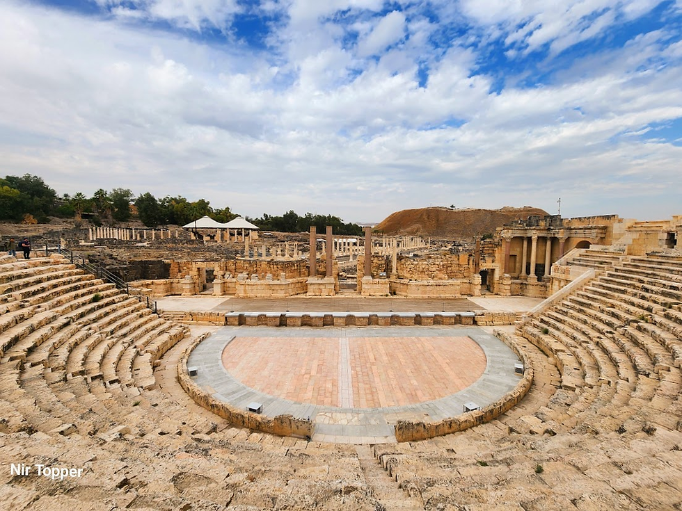
Image 2: Aerial view of the ancient theater. Source: By AVRAHAM GRAICER, CC BY-SA 4.0, https://commons.wikimedia.org/w/index.php?curid=44134289

Image 3: Inside the Roman bathhouse, Scythopolis. These small pillars are called hypocaust pilae (Latin for "stacks"). The hypocaust was the Roman underfloor heating system. The pilae supported the floor of the bathhouse and allowed hot air to circulate between them, heating the room from below. Photo: Nir Topper.

Image 4: A Greek mosaic inscription from the Byzantine period which gave the main street of Scythopolis its name: Palladius Street. It reads: "The work of the stoa and the mosaic decoration were done in the time of Flavius Palladius, son of Porphyrius, the most magnificent governor." Photo: Nir Topper.

Image 5: The columns of the Cardo, Scythopolis. Photo: Nir Topper.

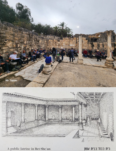
Image 6: A tour guide course sitting in the 2,000-year-old public latrines while listening to a lecture. Photo: Nir Topper. Illustration: Site signage.
--
---
----