
What did the road to Jerusalem really look like 1,700 years ago?
- Nir Topper

- 1 hour ago
- 4 min read
The Tabula Peutingeriana (Peutinger Table), one of the most fascinating geographic documents from the ancient world to have survived to our day, offers a rare window into the road network of the Roman Empire. The map served as a comprehensive road guide depicting the world known to the Romans—from Britain and the Iberian Peninsula in the west to India in the east—although the westernmost sheet, which included Spain and most of Britain, was lost and does not appear in the surviving copy. The document currently housed in the Austrian National Library in Vienna is a medieval copy, likely dating to the 13th century, of a Roman original from the 4th century CE. The author of the original map was likely a cosmographer named Castorius, though this remains uncertain. The surviving copy is drawn on an exceptionally long and narrow parchment scroll consisting of eleven sheets—nearly 7 meters long and only about 34 centimeters wide. The map is named after its owner, Konrad Peutinger (1465–1547), a German statesman and antiquarian.
The map is not drawn to scale and does not account for the true proportions of the various lands. Instead, the roads are represented by straight lines, along which settlements and the distances between them are marked, mostly in Roman miles (a Roman mile is 1,479 meters. This measure was based on 1,000 double paces of a Roman soldier (passus) and served as the basis for the placement of milestones). Major settlements were illustrated as a pair of towers with a gate between them, road stations were indicated by "zig-zag" breaks in the road line, and mountain ranges, rivers, and seas were also depicted. The map was compiled from lists of routes (itineraria) that specified stations and distances, making it similar in character to a modern transit map. It reflects the road network that served, among other things, the imperial "courier service" (cursus publicus), established by Augustus (63 BCE–14 CE) for delivering government correspondence, transporting officials, and moving tax revenues from province to province.
The Land of Israel Perspective
The Land of Israel appears in the ninth segment of the map and receives a detailed description, stretching from Syria in the north to the Nile Delta in the south. Interestingly, the elongated and narrow shape of the land fit well with the dimensions of the parchment strip: the country appears in the map "lying on its side," and its shape is less distorted than that of other regions. Jerusalem is marked with the inscription: formerly called Jerusalem, now Aelia Capitolina—and the Mount of Olives is noted nearby. One of the most surprising features of the Land of Israel's representation in the Tabula Peutingeriana is the use of anachronistic names (names from previous eras that did not correspond to the time the map was edited). Although the map was compiled in the 4th century CE, central cities in the Land of Israel appear by their ancient names. The explanation for this lies in the fact that the map's editor drew knowledge from ancient sources, the most important of which was the work of the geographer Ptolemy of Alexandria, who lived in the mid-2nd century CE.
The map is a fascinating "time capsule" of the Land of Israel:
Bet Guvrin, which was renamed Eleutheropolis around 200 CE, appears on the map by its ancient name, Betogabri.
Emmaus is listed as Amauante, even though its name was changed to Nicopolis in 221 CE.
Lod appears as Luddis, rather than its later name, Diospolis.
Paneas (Banias) appears in the interesting form Cesareapaneas—a combination of the name from the days of Philip son of Herod and the old Hellenistic name.
The coastal city of Dor is marked on the map as an active settlement called Thora, even though, according to Jerome's testimony, it already lay in ruins by the end of the 4th century.
These "outdated" names are key evidence that the description of the Land of Israel on the map is based on a source much older than the time of its compilation—likely from the 2nd century CE, before the Severan dynasty emperors gave the country's cities their new names. The Tabula Peutingeriana is a living and fascinating testament to how the inhabitants of the ancient world perceived the space of the Land of Israel, how they moved through it, and how geographic knowledge was transmitted (and sometimes corrupted) from generation to generation.
--
---
----
👉Join one of my (quiet) Channels, stay updated:
Telegram: nirtopper.com/telegram-channel
Whatsapp: nirtopper.com/whatsapp-channel
👉Rich content available for you on my Blog; Israel's History, Society & Culture:
Tabula Peutingeriana, 1-4th century CE. Facsimile edition by Konrad Miller, 1887/1888
Image: Konrad Miller, Public domain, via Wikimedia Commons

Jerusalem and the Mount of Olives on the Tabula Peutingeriana (marked in orange lettering); Emmaus is marked with a red circle.
Image: Conradi Milleri, Public domain, via Wikimedia Commons

Caesarea and the roads leading to it are highlighted in the circle (from the article by Prof. Israel Roll).
Image: The Israel Institute of Archaeology website.

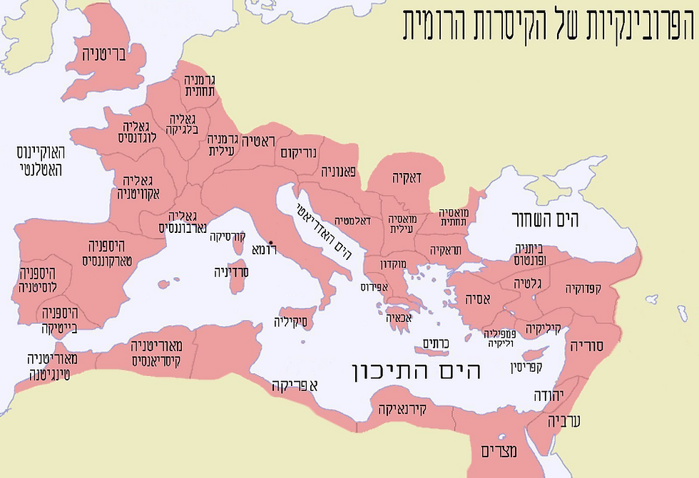
"All roads lead to Rome"

The Roman provinces after 120 CE, which were connected by the Roman road network.
Image: Ori~, CC BY-SA 3.0 <http://creativecommons.org/licenses/by-sa/3.0/>, via Wikimedia Commons
Combined data from the Peutinger Table and Antonine Itinerary recording the Roman roads network.
Image: Mellangoose, CC0, via Wikimedia Commons


Comments