Briefly from Current Events: The Galilee Panhandle
- Nir Topper
- 4 days ago
- 3 min read
The "Galilee Panhandle" (Hebrew: Etzba HaGalil, literally "Finger of the Galilee") is the name given to a region in northeastern Israel that juts out as an extension or "finger" from the country's contiguous territory northward into Lebanon. Its eastern border runs alongside the Golan Heights and the Jordan River. Until 1967, when Israel captured the Golan Heights from Syria, the Galilee Panhandle also served as the northeastern border of the State of Israel.
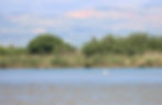
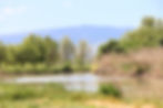
The territory of the Galilee Panhandle encompasses the Hula Valley and the eastern slopes of the Naftali Mountains. It is home to communities such as Kiryat Shmona—the largest city in the area with approximately 24,000 residents—Metula, Yesud HaMa'ala, and various moshavim and kibbutzim belonging to the Mevo'ot HaHermon and Upper Galilee Regional Councils. Route 90, Israel's longest highway, begins in Metula, travels south through the center of the Galilee Panhandle, and concludes at the Taba Crossing on the Israel-Egypt border, south of Eilat.
The fact that the Galilee Panhandle is an extension with such unique borders is not the result of natural topography, but rather a direct product of the post-World War I territorial partition agreements between the victorious powers—Britain and France.
The shaping of these borders evolved through a complex process. It began with the Sykes-Picot Agreement (1916), which initially designated the area for the French, and concluded with the signing of the Paulet–Newcombe Agreement in 1923, which was finally implemented with the physical demarcation of the border in April 1924. The primary catalyst for the northern border's route was the British interest in including the sources and the entire length of the Jordan River within their Mandate. Britain sought for Metula to serve as the "new Dan" (the biblical northern limit) and for the Jordan River to be defined as the "River of the Land of Israel."
Alongside the British interest, the presence of Jewish communities established in the area prior to the border's demarcation—namely Metula, Kfar Giladi, and Tel Hai—may have also contributed to the political feasibility of including the region in the British Mandate. However, the exact extent of their influence on the final decision remains a subject of debate among historians. Ultimately, in 1924, approximately 192 square kilometers and 20 villages were transferred from French to British control, incorporating the Galilee Panhandle into the territory that would eventually become the State of Israel.
The distinct shape of the Galilee Panhandle presents unique security and defense challenges. Metula, for instance, is the only community in the country surrounded by an international border on three sides. In Israel, we are accustomed to thinking of Lebanon as a country situated strictly to the north. However, in the Galilee Panhandle, Lebanon lies to both the north and the west of the region.
Furthermore, the local topography provides a significant advantage to the Lebanese side. The ridges across the border—including the Beaufort Ridge and the Nabatieh Plateau, as well as the Lebanese ridge directly overlooking Route 90 as it heads north—dominate the Galilee Panhandle. This elevated terrain allows for direct observation and the launching of projectiles toward the region's communities from heights that loom over the area with substantial elevation differences.
The historical decisions, agreements, and processes of the Land of Israel—in this instance, the demarcation of the international border—have dramatic, lingering consequences. The State of Israel continues to grapple with these ramifications today in its ongoing efforts to establish a secure and protected reality for the residents of this region.
--
---
----
👉Join one of my (quiet) Channels, stay updated:
Telegram: nirtopper.com/telegram-channel
Whatsapp: nirtopper.com/whatsapp-channel
👉Rich content available for you on my Blog; Israel's History, Society & Culture:
Image 1 - Map of the Galilee Panhandle region. Source: Google Maps

Image 2 - The border lines, as drawn in the Sykes-Picot Agreement (green) and the border line marked between the British and the French in 1924 (blue), which formed the basis for the current border between Israel and Lebanon.

Images from the Hula Valley showcasing the unique nature and landscape of the region, alongside the topographical and geographical challenges regarding the defense and security of the area. Photos: Nir Topper.